Consulting
Total Station Survey
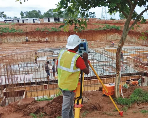
A Total Station Survey is a modern surveying method that integrates electronic distance measurement (EDM), angular measurement, and data recording into a single device called a total station. This equipment is widely used in the construction, civil engineering, and land surveying fields to measure distances, angles, and elevations with high precision.
Uses of Total Station Surveys
Land Surveying
Measuring boundaries, plotting land parcels, and creating topographic maps.
Construction
Setting out points for buildings, roads, and utilities.
Infrastructure Development
Surveying for bridges, highways, tunnels, and dams.
Mining and Excavation
Measuring excavation volumes and monitoring progress.
Mapping and GIS
Collecting data for geographic information systems (GIS).
Monitoring
Checking deformation in structures and landslides.
FAQs
Why is a total station survey important?
It ensures
- High accuracy in measurements.
- Faster survey execution compared to traditional methods.
- Digital data storage, reducing manual errors.
- Versatility for various applications like construction, mapping, and volume calculations.